The History of Hurricanes: Formation, History, Impact, and Modern Forecasting
The history of hurricanes stretches back thousands of years, long before modern meteorology, satellites, radar systems, aircraft observations, and computer forecasting models made it possible to monitor tropical storms from space. For generations, people living near tropical and subtropical oceans have witnessed the extraordinary power of these storms and have developed ways to recognize, understand, and prepare for them.
Hurricanes have influenced coastal communities, maritime travel, settlement patterns, construction practices, emergency planning, and scientific research. Although modern technology has dramatically improved the ability to observe and forecast tropical systems, hurricanes remain among the most powerful weather events on Earth.
Different cultures developed their own names, traditions, and explanations for powerful tropical storms. The English word “hurricane” is commonly associated with the Taino word “hurucan”, which was connected with a powerful storm or storm deity. The terminology reflects the long relationship between tropical storms and the communities that have experienced them throughout history.
What Is a Hurricane?
A hurricane is a powerful tropical cyclone that develops over sufficiently warm ocean waters. These storms are characterized by strong rotating winds, thunderstorms, heavy rainfall, and potentially dangerous coastal conditions.
The word hurricane is generally used for tropical cyclones that develop in the Atlantic Ocean and the northeastern Pacific Ocean. Similar weather systems occur in other parts of the world and are commonly known by different names. In the western Pacific, these systems are usually called typhoons, while in the Indian Ocean and parts of the South Pacific they are generally known as tropical cyclones.
Despite differences in terminology, these systems share many of the same basic characteristics. They are organized areas of low atmospheric pressure that develop over warm tropical or subtropical waters and can produce powerful winds, intense rainfall, thunderstorms, and dangerous coastal conditions.
How Hurricanes Form
The formation of a hurricane requires several important atmospheric and oceanic conditions to occur at the same time. One of the most important ingredients is sufficiently warm ocean water.
Tropical cyclones generally require sea-surface temperatures of approximately 26.5°C (80°F) or higher over a sufficient depth to provide the energy needed to support storm development. Warm ocean water provides heat and moisture to the atmosphere above it.
When warm, moist air rises from the ocean surface, it cools and can condense into clouds and thunderstorms. During condensation, heat is released into the atmosphere. This additional energy can help a developing weather disturbance become more organized.
A pre-existing weather disturbance is also commonly necessary. This disturbance may consist of an area of thunderstorms or a tropical wave moving through the atmosphere. If environmental conditions remain favorable, the disturbance can gradually develop a more organized circulation.
As the system becomes stronger, it may progress through several stages. It can first become classified as a tropical disturbance, followed by a tropical depression when a sufficiently organized circulation develops. If sustained winds increase further, the system can become a tropical storm. Once the required hurricane-strength winds are reached, it is classified as a hurricane in the Atlantic and northeastern Pacific.
The Role of Warm Ocean Water
The ocean plays a central role in the development and maintenance of hurricanes. Warm seawater provides energy and moisture that can fuel thunderstorms within a developing tropical system.
When a hurricane moves over cooler water, its primary energy source can become weaker. A similar reduction in strength can occur when a storm moves over land because it is no longer receiving energy directly from warm ocean water in the same way.
However, the behavior of hurricanes is influenced by many factors, and a storm does not always weaken immediately after encountering a change in environmental conditions. Atmospheric moisture, wind patterns, storm structure, and the characteristics of the underlying ocean can all influence how a tropical system evolves.
The Importance of Atmospheric Conditions
Warm water alone is not enough to guarantee hurricane development. The atmosphere also needs to provide conditions that allow a tropical system to remain organized.
Strong changes in wind speed or direction with altitude, commonly referred to as vertical wind shear, can interfere with the organization of a tropical cyclone. Lower wind shear can sometimes provide a more favorable environment for a developing system, while stronger shear can disrupt thunderstorms and make organization more difficult.
Atmospheric moisture is another important factor. A tropical cyclone generally benefits from a sufficiently moist environment because dry air can interfere with the thunderstorms that help maintain the storm’s circulation.
The Eye of a Hurricane
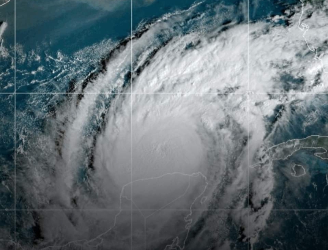
As a hurricane becomes stronger and more organized, it can develop a distinctive structure known as an eye. The eye is located near the center of the storm and can sometimes experience lighter winds and fewer clouds than the surrounding areas.
The eye is surrounded by the eyewall, a ring of powerful thunderstorms. Some of the strongest winds and most intense rainfall in a mature hurricane are generally found within or near this region.
The structure of the eye and eyewall can change throughout the life of a hurricane. Some powerful hurricanes experience changes in their eyewall structure that can temporarily alter the storm’s intensity or size.
Rainbands and Hurricane Structure
Hurricanes are not simply large areas of wind surrounding an eye. They contain complex bands of thunderstorms known as rainbands. These bands can extend far outward from the center of the storm and produce periods of heavy rainfall, strong winds, and thunderstorms.
Because rainbands can extend well beyond the eyewall, dangerous weather may occur hundreds of miles from the center of a tropical system. This is one reason why residents should not assume that conditions will remain safe simply because they are not located directly in the projected center of the storm.
Why Hurricanes Can Be Dangerous
Hurricanes can affect communities in several different ways. Strong winds can damage buildings, trees, power lines, roads, communication infrastructure, and other structures.
Heavy rainfall can create widespread flooding, particularly when a slow-moving tropical system remains over an area for an extended period. Flooding can occur along rivers, streams, low-lying areas, and urban locations where drainage systems become overwhelmed.
Coastal communities face additional risks from high waves and storm surge. These hazards can cause significant damage even when the strongest winds of the hurricane occur farther offshore.
Understanding Storm Surge
Storm surge refers to an abnormal rise in seawater associated with a storm, primarily caused by the storm’s winds pushing water toward the coast and influenced by atmospheric pressure and coastal geography.
Storm surge can become particularly dangerous in low-lying coastal areas. The exact level of surge experienced at a particular location depends on several factors, including storm intensity, size, angle of approach, coastline shape, water depth, tides, and the characteristics of the local shoreline.
Because storm surge can move inland and cover roads, neighborhoods, and other areas near the coast, it is an important part of hurricane preparedness.
Hurricane Categories
In the Atlantic and northeastern Pacific, hurricanes are commonly classified using the Saffir-Simpson Hurricane Wind Scale. The scale ranges from Category 1 through Category 5 and is based on sustained wind speeds.
- Category 1: The lowest hurricane category, but still capable of causing damage to property, vegetation, and infrastructure.
- Category 2: A stronger hurricane capable of causing more significant damage, including damage to structures and widespread power disruptions.
- Category 3: A major hurricane with the potential for severe damage to buildings, infrastructure, vegetation, and utilities.
- Category 4: An extremely powerful hurricane capable of causing catastrophic damage in affected areas.
- Category 5: The highest category on the scale, associated with extremely powerful winds and the potential for catastrophic damage.
The category of a hurricane is based specifically on sustained wind speed. It does not describe every potential hazard associated with a storm. A lower-category hurricane can still produce dangerous flooding, rainfall, storm surge, or tornadoes depending on the circumstances.
The History of Hurricane Observation
People have been observing tropical storms for centuries. Before the development of modern scientific instruments, sailors and coastal residents relied heavily on visible and environmental signs to recognize approaching severe weather.
Changes in wind direction, rapidly developing clouds, unusual waves, falling atmospheric pressure, and other environmental clues could indicate that a powerful storm was approaching.
Historical accounts from sailors and explorers provide some of the earliest written descriptions of major tropical storms. These records are valuable because they provide information about how storms affected people before modern weather observation networks existed.
Early Records of Atlantic Hurricanes
One of the earliest well-known recorded encounters with a hurricane dates back to 1495, when Christopher Columbus encountered a powerful storm in the Caribbean during his voyages.
Historical accounts from that period describe severe winds and dangerous sea conditions. Such observations helped demonstrate the immense power of tropical storms to European observers who had limited experience with these weather systems.
Over the following centuries, hurricanes continued to be documented throughout the Caribbean, the Gulf of Mexico, and along the eastern coast of what is now the United States.
Early records were often incomplete, however, because there were no standardized weather instruments or organized systems capable of tracking storms across large areas of the ocean.
Hurricanes Before Modern Forecasting
For much of history, communities had very limited warning before a major hurricane arrived. Mariners depended on observations of wind, clouds, waves, atmospheric pressure, and other natural signs.
Coastal residents often had little choice but to react when a storm was already approaching. Without modern communication systems, information about a storm could take considerable time to travel from one community to another.
As populations expanded along coastal areas, hurricanes increasingly affected larger numbers of people and greater amounts of infrastructure. Powerful storms could damage homes, destroy crops, disrupt transportation, flood communities, and cause substantial economic losses.
The Development of Modern Meteorology
The 20th century brought major advances in meteorology. Improved weather instruments allowed scientists to collect more consistent observations of atmospheric conditions.
Communication technology also made it easier to share weather observations over long distances. Aircraft eventually provided another important source of information by allowing scientists and meteorologists to observe tropical systems directly.
One of the major developments in the United States was the establishment of the National Hurricane Center in 1965. It became an important part of hurricane monitoring, forecasting, and public safety efforts.
As forecasting methods improved, authorities gained better tools for communicating potential threats to communities in the path of tropical systems. More accurate observations and improved communication meant that people could receive warnings earlier than previous generations.
The Arrival of Weather Satellites
The development of weather satellites represented a major change in the way hurricanes were observed. Before satellites, large portions of the world’s oceans remained difficult to monitor continuously.
Satellite observations made it possible to monitor tropical systems over large areas of the ocean. Meteorologists could observe cloud patterns, storm organization, movement, and other characteristics without relying entirely on observations from ships or aircraft.
Over time, satellite technology became increasingly sophisticated. Modern satellites can provide frequent observations that help meteorologists follow changes in tropical systems and identify developing areas of organized convection.
Aircraft and Hurricane Research
Aircraft observations have also played an important role in hurricane research and forecasting. Specialized aircraft can enter or fly around tropical systems to collect measurements that cannot be obtained as easily from the ground.
Instruments can measure atmospheric pressure, temperature, humidity, wind, and other conditions. These observations can provide valuable information about the internal structure and intensity of a storm.
Aircraft data can be combined with satellite observations, surface measurements, ocean information, and computer models to create a more complete picture of a developing hurricane.
The Rise of Computer Forecasting Models
One of the most important developments in modern weather forecasting has been the use of numerical computer models.
These models process large amounts of atmospheric and oceanic information and use mathematical equations to estimate how weather conditions may evolve over time.
For hurricanes, forecasting models can help meteorologists estimate potential storm tracks and changes in intensity. Several different models may be examined because no individual model can perfectly predict the future behavior of a complex tropical system.
Forecast uncertainty remains an important part of hurricane prediction. Small differences in atmospheric conditions can sometimes produce significant differences in a storm’s future track or intensity.
Hurricane Watches and Warnings
Modern emergency systems use different types of alerts to communicate potential hurricane threats.
A hurricane watch generally indicates that hurricane conditions are possible within a specified area and time period. A hurricane warning generally means that hurricane conditions are expected or occurring within the specified area and time period.
The exact wording, timing, and geographic coverage of official alerts can change as forecasts are updated. Residents should always follow the latest information issued by the appropriate official weather and emergency-management authorities.
The Human Impact of Hurricanes
Hurricanes can have effects that extend well beyond physical damage. Communities may experience interruptions to electricity, transportation, communication, water services, businesses, schools, and other essential activities.
Recovery can take time, particularly after storms that cause widespread flooding or structural damage. Local governments, emergency responders, utility companies, community organizations, and residents may all play roles in the recovery process.
Repeated hurricane impacts have also encouraged communities to improve emergency plans and develop strategies designed to reduce future risks.
How Hurricanes Changed Building Practices
The experience of repeated storms has influenced building standards in many hurricane-prone regions. Stronger construction methods, improved roofing practices, storm-resistant windows, elevated structures, and other measures can be used in areas exposed to hurricanes.
Building practices vary depending on local regulations, geography, flood risk, storm exposure, and other factors. The goal of many such measures is to reduce the vulnerability of buildings and infrastructure when severe weather occurs.
Hurricane Preparedness
Preparation is an important part of reducing the potential impact of a hurricane. Residents in areas that may experience tropical storms can monitor official weather information and understand local emergency procedures before a storm threatens.
Preparedness may include knowing evacuation routes, understanding local alerts, protecting important documents, securing outdoor items, and making arrangements for potential interruptions to electricity or transportation.
Families may also develop communication plans so that members know how to contact one another if normal communication becomes difficult.
Because hurricane conditions can change quickly, people should pay attention to updated information from reliable weather and emergency-management authorities rather than relying exclusively on older forecasts or unverified information shared online.
Hurricanes and Coastal Geography
The effects of a hurricane can vary significantly from one location to another. Coastal geography, elevation, river systems, wetlands, barrier islands, bays, and the shape of the shoreline can all influence how storm hazards affect a community.
For example, two communities located relatively close to one another may experience different levels of flooding or storm surge because of differences in elevation and coastal shape.
This is one reason why hurricane forecasts and warnings often provide information for specific areas rather than treating an entire coastline as having identical conditions.
Hurricanes and Inland Areas
Although hurricanes are commonly associated with coastal communities, their effects can extend far inland.
Heavy rainfall can continue after a storm moves away from the coast, potentially causing river flooding and other water-related hazards. Strong winds can also affect inland communities, especially when a tropical system maintains significant strength after landfall.
For this reason, residents well away from the coastline should not automatically assume that they are outside the potential impact area of a hurricane.
Hurricane Size and Intensity
Hurricane intensity and hurricane size are not the same thing. A storm can have extremely strong maximum winds while affecting a relatively limited area, while another storm may have a much larger wind field.
The overall impact of a hurricane depends on more than its category. Storm size, forward speed, rainfall, storm surge, geography, and local conditions can all influence the hazards experienced by a particular community.
Why Hurricane Forecasts Change
It is normal for hurricane forecasts to change as new observations become available. Meteorologists continuously receive updated information from satellites, aircraft, weather stations, ocean instruments, and other sources.
Computer models are then updated with new data. As a result, the projected path or intensity of a hurricane can shift over time.
This does not necessarily mean that earlier forecasts were inaccurate. Rather, forecasting is an evolving process in which scientists refine their estimates as they receive more information about the atmosphere and ocean.
Hurricanes in the Modern Era
Today, hurricanes can be monitored more closely than at almost any other time in history. Satellites can observe tropical systems across large sections of the ocean, while sophisticated computer systems process enormous quantities of weather information.
Modern communication technology also allows forecasts and warnings to reach the public through television, websites, mobile devices, social media, emergency alert systems, and other channels.
This combination of observation, forecasting, and communication has significantly changed how communities prepare for hurricanes compared with previous centuries.
The Continuing Challenge of Hurricane Forecasting
Despite major technological advances, forecasting hurricanes remains challenging. Tropical systems interact with a constantly changing atmosphere and ocean, and even relatively small environmental changes can influence their development.
Forecasting the general movement of a hurricane has improved significantly over time, but uncertainty remains, especially when estimating intensity changes and the exact location of future impacts.
For this reason, forecasts are updated regularly, particularly when a storm approaches land or when new observations indicate that conditions have changed.
The Future of Hurricane Forecasting
Scientists continue to develop new methods for improving hurricane observations and forecasts. Advances in satellite technology, atmospheric modeling, ocean measurements, artificial intelligence, data processing, and high-performance computing may provide additional tools for understanding tropical systems.
Future forecasting systems may be able to process increasingly detailed observations and identify subtle changes in storm structure or environmental conditions.
Even as technology improves, communicating uncertainty clearly will remain important. A useful forecast is not simply about predicting where a storm might go; it is also about helping people understand the range of possible outcomes and the hazards that may affect their communities.
Looking Back at the History of Hurricanes
The history of hurricanes illustrates how dramatically the understanding of severe weather has changed. Early communities relied on observation and experience, while modern meteorologists have access to satellites, aircraft, radar, ocean measurements, and advanced computer models.
Historical hurricane records also provide an important perspective on the long relationship between tropical storms and human communities. Over centuries, storms have influenced settlement patterns, maritime activity, construction practices, emergency planning, and scientific research.
Each generation has contributed to a better understanding of these complex weather systems. The progress from handwritten observations to near-real-time satellite monitoring represents one of the most significant developments in the history of weather science.
Conclusion
Hurricanes have been part of human history for thousands of years. From early observations by indigenous communities, sailors, and explorers to today’s advanced forecasting systems, people have continuously worked to understand these powerful tropical storms.
The formation of a hurricane depends on a combination of warm ocean water, atmospheric moisture, a pre-existing disturbance, and favorable atmospheric conditions. Once a tropical system becomes organized, it can develop an eye, eyewall, rainbands, powerful winds, heavy rainfall, and other hazards.
Over time, improvements in meteorology transformed the way hurricanes are observed and forecast. The development of weather instruments, aircraft observations, satellites, radar, computer models, and specialized forecasting organizations has provided communities with much more information and more time to prepare.
Nevertheless, hurricanes remain powerful and potentially dangerous natural phenomena. Their effects can include strong winds, storm surge, flooding, heavy rainfall, infrastructure damage, and disruption to communities.
Understanding the science and history of hurricanes can help explain why preparation, accurate information, and responsible decision-making remain important whenever a tropical system threatens a populated area.
The continuing development of forecasting technology offers opportunities for even better observations and predictions in the future. At the same time, the long history of hurricanes serves as a reminder that preparation and respect for severe weather remain essential.